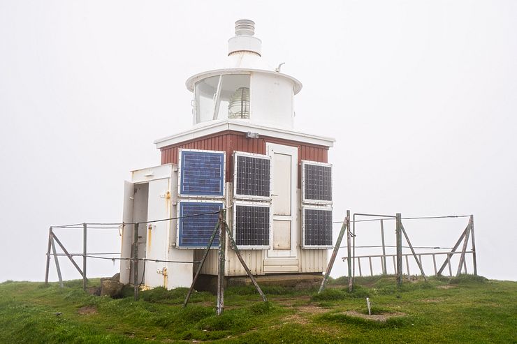
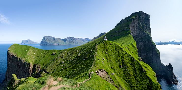
Kallur lighthouse on Kalsoy
January 5, 2020 20 min read
At Kallur, the northern tip of Kalsoy, stands a small lighthouse that doesn’t look much for the world. And yet it is the number one reason for many travelers to visit the Faroe Islands.
The lighthouse may be unremarkable, but the location where it stands perched on a high rock is breathtaking.
The hike to the lighthouse was supposed to be the highlight of my first trip to the Faroe Islands back in 2018. After seeing so many stunning photos from this epic location, I couldn’t wait to experience Kallur in person.
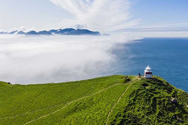
The day at Kalsoy turned out to be the total opposite of epic. It was a miserable day in every way possible, all because of an impenetrable fog and a nagging rain. On the hike to Kallur, I wandered off the path in the heavy fog. My feet got soaked walking through thick wet grass and the rain kept falling.
I arrived at the lighthouse only to find it engulfed in low clouds and the visibility was close to zero. I waited for a few hours, but the fog stayed where it was and I left Kallur seeing nothing but a white pea soup. It was a huge disappointment to say the least.
Before leaving the lighthouse, I promised myself to return to Kallur someday. I went back one year later, and what a difference it was! The sun was shining from a clear sky and I had an amazing time at Kallur.
I recommend everyone traveling to the Faroe Islands to visit Kalsoy. This post contains all information you need to plan the half-day trip to the lighthouse.
Kalsoy is the composition of kallur (man) and oy (island), the Man Island. Kunoy, the island to the east of Kalsoy, is the Woman Island (kona + oy).
Getting to the lighthouse requires a bit of planning because there is no tunnel or bridge to Kalsoy. You must take a ferry, continue by car or bus and finally do a short hike to reach Kallur. It’s easy, but there are a few things you should know for the day to run smoothly during peak season when many tourists travel to Kalsoy.
If you are considering joining a guided tour to Kalsoy, see the Tours to Kalsoy and the Kallur lighthouse section at the end of this post for tour suggestions.
Let’s start with a summary of the logistics, a typical day trip to Kalsoy looks like this:
See the interactive map below for points of interest on Kalsoy. Click on a marker for more information.
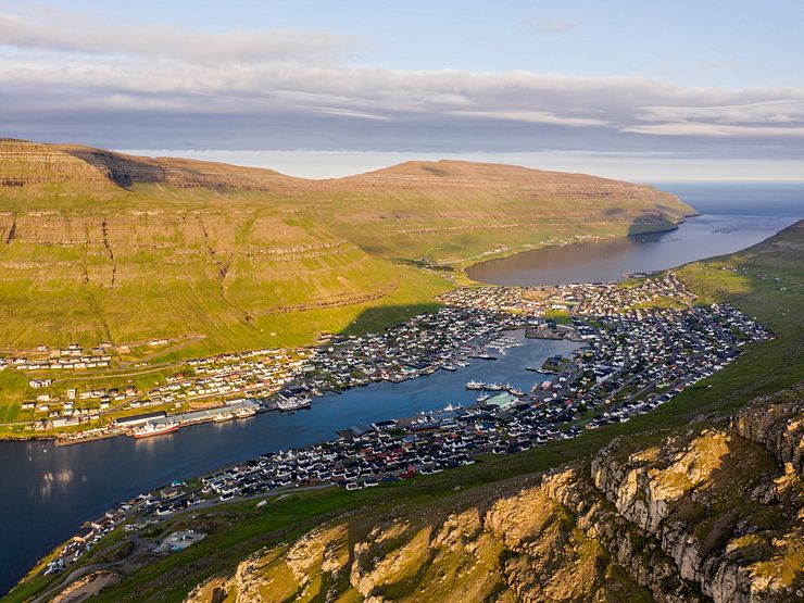
Klaksvík on the island of Borðoy is the second largest town in the Faroe Islands with a population of 5.200. A road tunnel connects Borðoy with Eysturoy so you can either drive or take the bus to Klaksvík.
It’s a 40km (25 miles) drive (45m) on a good road from Tórshavn to Klaksvík. It used to take over one hour, but Eysturoyartunnilin, the new undersea tunnel completed in 2020, shortens the drive considerably. Driving from the airport takes about 1h15m.
There are bus connections to Klaksvík from several towns. From Tórshavn, take either bus 400 (1h30m) or the express line 401 (1h5m).
If you are taking the early morning ferry to Kalsoy, it’s convenient to stay in Klaksvík the night before to get an extra hour of sleep. Accommodation around Klaksvík is limited so make enquiries in good time. All places were booked during my trips and I made the early morning drive from Tórshavn instead.
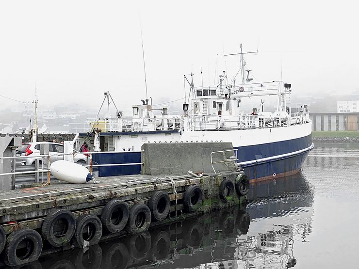
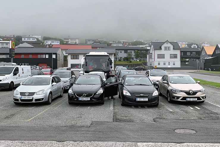
The ferry to Syðradalur on Kalsoy departs from the port in Klaksvík (Google Maps Ferjulega, coordinates: 62.23044, -6.58894). Advance ticket booking isn’t possible, it’s first come, first served. The cars line up in lanes waiting to board the ferry.
Timetables for line 56 Klaksvík - Syðradalur are available at ssl.fo, one for summer and one for winter. Remember to check if your travel date deviates from the regular timetable should you for example take the ferry on a national holiday.
The earliest departures to Syðradalur are 06:40 on weekdays, 08:00 on Saturdays and 10:00 on Sundays. The last regular departures back to Klaksvík are 18:50 on weekdays and 17:35 on weekends. A late departure from Syðradalur at 22:35 is available on request by phone no later than 19:00 on the same day.
The ferry ride takes 20 minutes and a return ticket cost DKK 40 for adults and DKK 160 for a car including the driver (2022). Cash and credit cards are accepted and you pay to the staff before boarding the ferry.
Should you leave your car in Klaksvík and walk on the ferry, there are parking spaces nearby. The parking was free of charge when I used it.
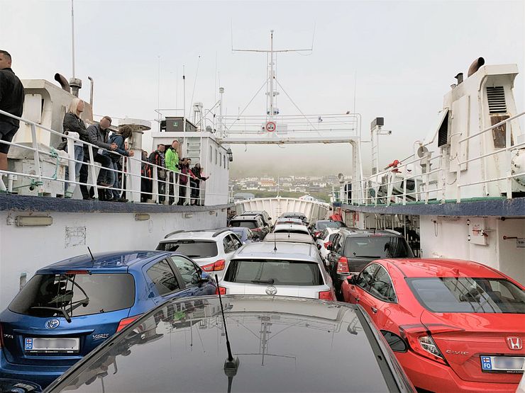
To secure a spot for your car on the ferry during the summer, you must show up early. The vehicles stand bumper-to-bumper on the ferry, but the capacity is still only about 17 cars. Sometimes even less if a tourist bus or a truck is among the vehicles.
When I took the 08:00 ferry on a Tuesday in July 2018, I arrived 35 minutes before the departure time and there was room on the ferry. The ferry filled up and two cars were left in the port. On a Saturday in early August 2019 I intended to take the 10:00 departure and showed up at 09:30, but the port was already full of cars. I left the car at a parking and walked on the ferry instead. There is always room for walk-on passengers.
It’s hard to say how early you have to show up, it depends on the season, the day of the week and which departure you take. I would say at least an hour before for the most popular departures.
The guys operating the ferry told me that if they cannot take all the cars onboard, they often come back to do an extra crossing. It depends on how many cars that couldn’t make it on the ferry.
The same routine applies when leaving Kalsoy. I wouldn’t recommend it, but if you are planning to visit Kallur on your last day and drive straight to the airport from Klaksvík, then you’d better show up extra early for the ferry in Syðradalur.
If you don’t intend to stay in the car during the crossing, it’s best if any passengers walk onboard. Fold in the side mirrors before driving on the ferry and let the staff direct you to your spot on the car deck. They position the cars tight to use all the available space.
In general it’s a breeze to travel around with a car in the Faroe Islands. It’s easy driving on good roads with light traffic and short distances between attractions. The only nuisance I’ve experienced is the Kalsoy ferry. It’s an infrastructure bottleneck during peak season and with the increasing number of tourists it will only get worse until they increase the capacity on the route.
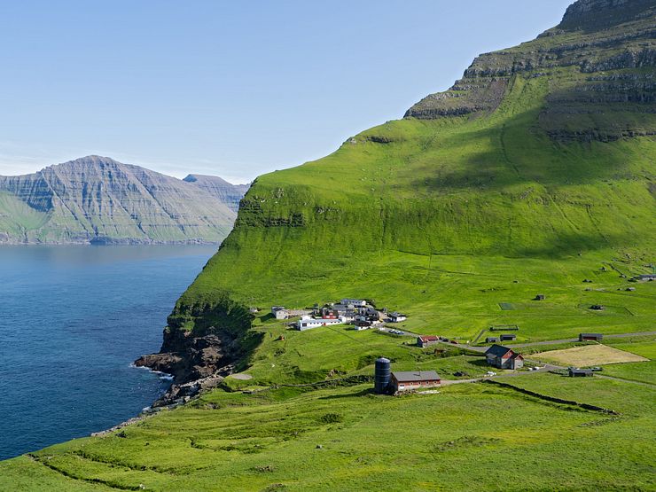
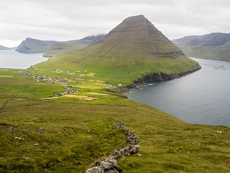
After disembarking from the ferry in Syðradalur there is only one way to go, and that’s north. The single road on Kalsoy connects Syðradalur in the south with Trøllanes in the north. The drive to Trøllanes is 17km (10.6 miles) and takes 20 minutes. From the village, it’s a short hike to the Kallur lighthouse.
The narrow road passes through four dark single-lane tunnels. The tunnels are, from south to north, Villingardalstunnilin 1193m (3914ft), Ritudalstunnilin 683m (2241ft), Mikladalstunnilin 1082m (3550ft) and Trøllanestunnilin 2248m (7375ft).
Kalsoy is called the flute because of the island's tall, narrow shape and the road tunnel openings looking like flute finger holes.
If this is your first time driving through a single-lane tunnel, check out the driving information videos at Landsverk. The single-lane tunnels have turnouts every 100m (328ft). When you have the turnouts to the right, you must give way to oncoming traffic. An exception is when you meet a truck, then you should always give way. It’s easy to drive in the tunnels, just keep the headlights on and don’t drive too fast.
I didn’t make a video of the tunnel drive on Kalsoy, but I have one from the Gásadalur tunnel on Vágar so you can get an idea of how it’s like. That tunnel is lit while the Kalsoy tunnels are dark, but the experience is similar.
After exiting from the last tunnel, you have a nice view of the Trøllanes valley while driving the curvy road down to the village. From the parking (coordinates 62.36150, -6.78864), it’s just a short walk to the start of the lighthouse hike.
If you don’t take your rental car on the ferry, you must take the bus to Trøllanes instead of driving. Bus 506 runs between Syðradalur and Trøllanes with stops in Húsar and Mikladalur (on request when northbound). The ride takes 30-35 minutes, and the bus stops at the parking in Trøllanes.
The bus timetable is coordinated with the ferry schedule and the bus is waiting in the port when the ferry arrives at Syðradalur. If I remember correctly, a one-way ticket to Trøllanes costs DKK 20 (2019). I paid in cash, I don’t think they accept credit cards.
On my second visit to Kalsoy the ferry was full, and I left the car in Klaksvík. I was not the only one doing that because when I was about to jump on the bus in Syðradalur the driver said it was full and that he would be back for the rest of us in about 50 minutes.
If the ferry is full of walk-on passengers, it’s best to go to the far end of the ferry when boarding. You can then be one of the first off the ferry and walk straight to the bus. The bus is something in between a minibus and a full-size bus.
Kalsoy has 4 villages, 11 valleys and 13 peaks. Approximately 40 persons live in the largest village, Húsar, and the total population of the island is less than 100 (2015).
I didn’t feel like waiting for the bus so I hitchhiked to Trøllanes. Hitchhiking is safe in the Faroe Islands and if you don’t have a rental car, it’s an option where buses are infrequent. I picked up several hitchhikers myself during the trip and they all said it was easy to get a ride.
A good thing with taking the bus is that you don’t have to worry about showing up early in Syðradalur for the ferry back to Klaksvík. I had no problem getting a seat on the bus in Trøllanes, but it filled up in Mikladalur. A few tourists couldn’t get on the bus and missed the ferry.
Trøllanes (Troll peninsula) is the second northernmost village in the Faroe Islands, beaten only by Viðareiði on the Island of Viðoy. The small village is home to about a dozen persons. Next to the parking in Trøllanes is a public toilet and there is a café in the village. When standing at the parking, the village is to the south and the start of the lighthouse hike is to the north.
The hike to Kallur is short, about 1.6km (1 mile) one-way from Trøllanes. It’s an easy 40-60 minutes hike and returning to Trøllanes is somewhat faster because the lighthouse is at a higher elevation than the village.
I’ve done the hike twice, one time in heavy fog and one time in clear weather. I lost track of the path early on in the fog and it took me one hour to reach Kallur. Walking through thick grass slowed me down. With better weather it was easy to follow the path, and I did the hike in 40 minutes including photo stops.
The landowner doesn’t collect a fee from tourists for doing the hike (August 2019). I wouldn’t be surprised if this will change considering how popular the hike is.
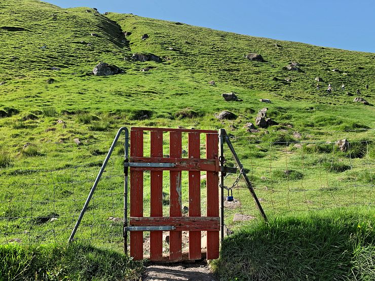
From the parking, walk on the road in the direction away from the village. You will pass a building to your right and the road turns into a path leading to a red wooden gate. Enter through the gate and close it carefully after you.
The path to the lighthouse is unmarked (August 2019), but it’s well-trodden during the summer and it should be straightforward to follow. Finding the lighthouse isn’t difficult, I could do it even in heavy fog, but if you don’t walk on the path, it’s a harder hike.
Pay attention at the start of the trail, that’s the only place where you risk walking off the path. Standing at the red gate, you have the Borgarin mountain to the left and the Atlantic Ocean to the right. The ideal path goes around the base of the mountain, not too high up or too low down on the slope.
Looking up the hill in front of you, there is no obvious landmark to take aim at on the crest. From the gate, several narrow paths and sheep trails lead towards the hill. Follow the clearest one taking you diagonally up the hill and to the right.
Kallur and Kalsoy are featured in the 2021 James Bond movie No Time To Die.
The mistake I’ve seen several hikers do here (I did it myself in the fog) is to deviate from the path and walk too much to the right. Doing this, you follow a route closer to the sea without much of a path to walk on. If you are walking close by some old sheep shelters, you are probably too low down on the slope and have the path somewhere higher up.
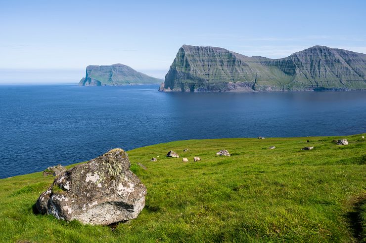
If you are blessed with clear weather during the hike, you will have a nice view of the Atlantic Ocean and the islands Kunoy and Viðoy to the east. The ever-present Faroese sheep are chewing away at the succulent grass along the path. Before you know it, you will arrive at the lighthouse.
I used an app on my phone to track the path I walked from Trøllanes to Kallur. The waypoint coordinates are available for download as a GPX file. The file can be imported in any map application supporting the GPX format.
Another option is to save some waypoints in the Your places section in your Google Maps account. The waypoints will be visible as markers on the map. If you download the Kalsoy map for offline use in Google Maps on your phone, you can follow the waypoints on the map even if you don’t have internet access in the Faroe Islands.
Note that the Kallur lighthouse point of interest position in Google Maps appears to be incorrect. OpenStreetMap has the lighthouse at the correct position and the hiking path plotted on the map.
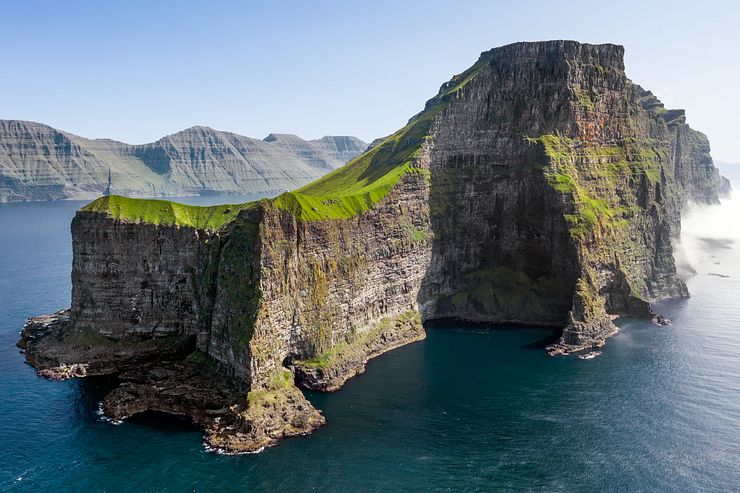
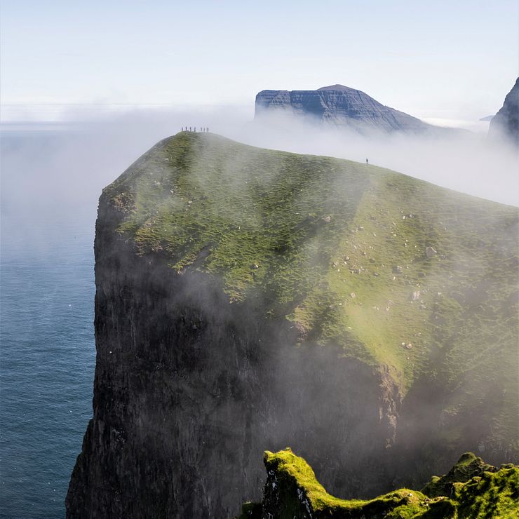
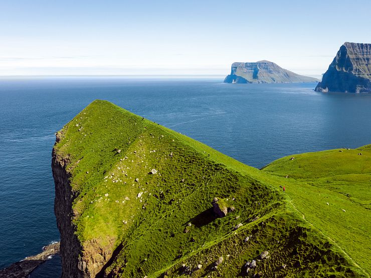
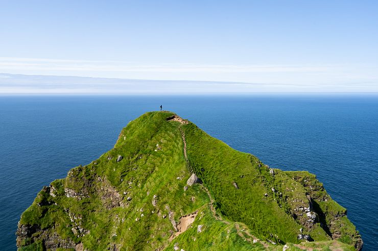
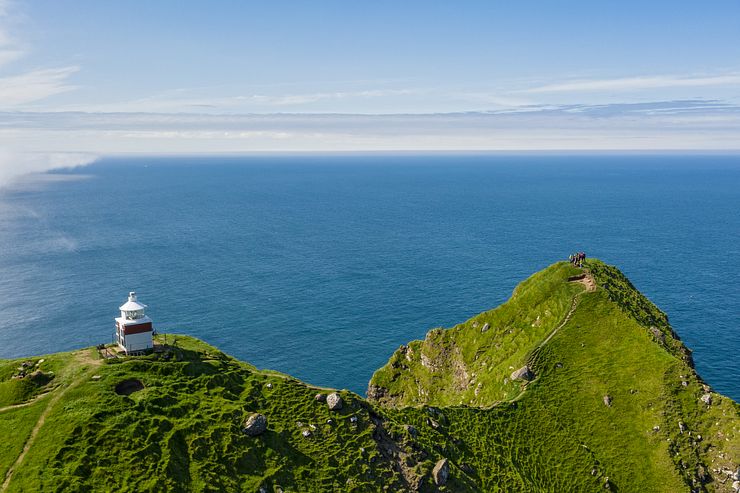
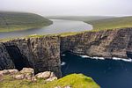
The Kallur lighthouse stands at a spectacular spot where two ridges meet. The lighthouse itself is small and nothing extraordinary, but it’s the focus point of all the amazing photos from Kallur. From the lighthouse, one ridge extends to the north and one to the east. Behind the lighthouse rises the Borgarin mountain with its sheer cliff facing the ocean.
The island of Eysturoy is to the west of Kalsoy. On a clear day you can see the Risin and Kellingin sea stacks north of Eusturoy (see photo earlier in the post).
Viewed at a distance, the pyramid-shaped eastern ridge looks razor-sharp, but it’s easy to walk on. It was crowded over at the lighthouse viewpoint so I found a nice place along the ridge to sit down a while and have my packed lunch.
From the eastern ridge, you have a nice side view of the lighthouse and the northern ridge with the cliffs of Eysturoy in the background.
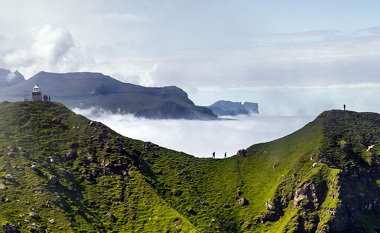
To reach the viewpoint where everyone takes the photo of the lighthouse with Borgarin in the background, you must cross the northern ridge. From some angles, the ridge looks intimidating with steep drops on both sides and many blog posts describe it as not for the faint-hearted.
On a clear, calm day, walking the ridge is not that bad. During my visit, people walked back and forth on the ridge seemingly without problems. Should you come on a day with strong winds or after heavy rainfalls when the path is slippery, it’s a different matter. Take extra caution when crossing the ridge in bad weather, it can be dangerous if you lose your footing in the wrong place.
If you have a problem with heights, you will not feel comfortable on the ridge, that’s for sure. Consider using a pair of trekking poles for additional stability.
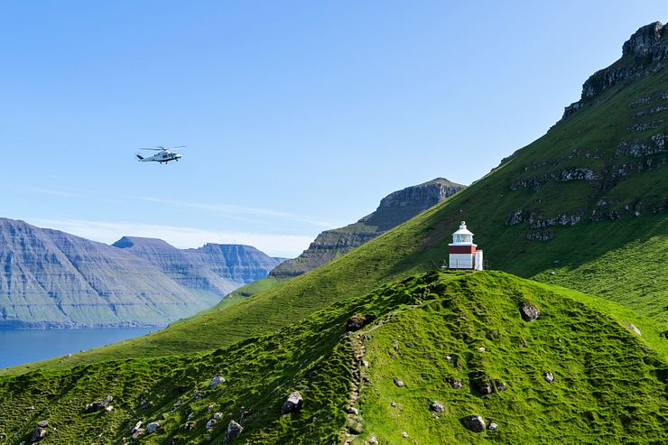
Kallur is a terrific place to fly a drone, you will bring home great aerial photos and videos. It can be risky though, beware of the strong winds often blowing around the rock and fly with caution.
It surprised me to see a helicopter flying by the lighthouse at low altitude. I didn’t know they are doing sightseeing tours by helicopter. When you have the drone in the air, watch out for helicopters and be prepared to move the drone out of the way.
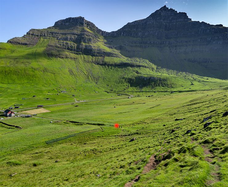
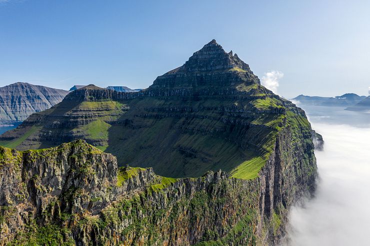
Most people hike to the lighthouse, walk the ridges and take some photos before returning to Trøllanes. If you have time, consider doing a detour to the top of the Borgarin mountain (537m, 1762ft) on the way back to the village.
I had planned to hike up to the peak, but I spent way too much time at the lighthouse taking photos, flying my drone and relaxing in the sun. I had to skip Borgarin this time, but it’s on my list should I ever return to Kalsoy.
You get a different perspective on the lighthouse from the peak. To the south is a ragged ridge going from Borgarin to the Slættafjall mountain (757m, 2484ft). The Trøllanes valley is between the two mountains. I flew the drone close to Borgarin to take a photo and the view towards Slættafjall is dramatic.
I don’t think hiking to the top of Borgarin is difficult, but I haven’t done it myself. For an idea of which route to take, check the path from the lighthouse to Borgarin plotted on OpenStreetMap (you might have to zoom to see the path).
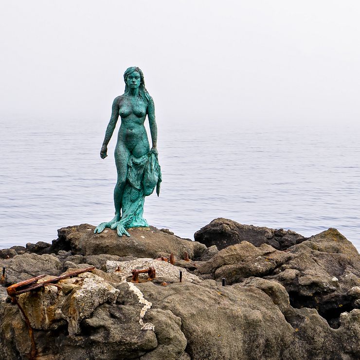
It’s popular to make a stop in Mikladalur when driving back to the ferry in Syðradalur. On a rock at the shore outside Mikladalur stands a statue of Kópakonan, the seal woman. A folktale tells the story of humans turned into seals coming ashore in the night once a year. The seals shed their skins and transform into humans. Delighted by being in their human shapes for a night, they dance until dawn.
While the other seals returned to the sea, Kópakonan was trapped on land because a young man hid her sealskin. The two married and got children, but when the seal woman found her hidden skin, she left her family and became a seal once again.
"Seals are humans, who took their own lives by drowning in the sea. According to the legend, once a year, on the Eve Of the Three Kings, the seals gather on the shore of Mikladalur. They shed their sealskins, become human again..." -- From The Seal Woman legend
Similar legends involving seal folk are also part of Scottish and Icelandic Folklore.
The legend is one of the most well-known myths in the Faroe Islands and you can read it on an information sign in Mikladalur. To meet Kópakonan, walk down the stairs to the stony beach. The statue is 2.6m (8.5ft) tall and made of bronze and stainless steel.
A place on Kalsoy I think few tourists even know about is the uninhabited valley of Djúpidalur. It’s accessible via a side tunnel branching off (coordinates 62.345720, -6.782123) from Trøllanestunnilin, the northernmost of the four main road tunnels on Kalsoy. The side tunnel, Teymur í Djúpadal, is 200m (720ft) long. I haven’t visited the valley myself so I don’t know if it’s beautiful or not, but if you have the time, why not make the turn and check it out?
During the summer you’ll stand a better chance of having decent weather, but you may have to deal with the hassle of full ferries. The off-season brings unstable weather, but on a good day you will probably enjoy Kallur more with fewer people around.
Spontaneous comment by a hiker upon reaching the lighthouse: "It doesn’t look like in the pictures!". No it doesn't, not until you have crossed a ridge to stand at the northernmost tip of Kallur.
Is it best to go early or late in the day? I’m not sure, but I’ve been to the lighthouse twice (morning ferries) and both times the morning was foggy and the evening was clear. Should I go to Kalsoy again, I would go in the early afternoon and take the last regular or the late 22:35 ferry back (available by phone request). With a promising weather forecast I would try to stay the night at Kalsoy for a chance to see Kallur at sunset.
It’s difficult to get good photos early in the day if it’s sunny. You will have the sun in front of you when taking photos of the lighthouse. Considering the rough Faroese weather, this will probably not be an issue for most, but I thought I’d mention it as I had problems getting decent photos at Kallur.
Accommodation is scarce on Kalsoy, but there are a few AirBnbs and a campsite on the island. Staying at the island gives you the choice of being at the lighthouse for sunrise and sunset. The drawback is that if you reserve accommodation long in advance, you will not know what the weather will be on your day at Kalsoy. If you have a flexible itinerary, you can go to the lighthouse on a clear day.
A day at Kalsoy is perfect to combine with the short hike to the Klakkur mountain near Klaksvík. I did the hike in the evening after visiting Kalsoy and several locals came from Klaksvík to see the sunset from the top.
Viðareiði on the island of Viðoy is the northernmost village in the Faroe Islands. The village is 19km north of Klaksvík, a 25 minute drive. Hike up Villingadalsfjall for a great view of Viðareiði and the cone-shaped Malinsfjall mountain. If you are a strong hiker, you can continue all the way to Cape Enniberg (754m, 2474ft), the second-highest sea cliff in Europe.
It’s not necessary to hike to the top of Villingadalsfjall to get a nice view. It was cloudy when I visited and I turned around before reaching the top. Walking 45-60 minutes (very individual of course) on the path from the village should be enough to reach a good viewpoint.
This section contains affiliate links. When you make a purchase of a tour through a link, I may earn a small commission at no extra cost to you. Thanks for your support — it helps keep the site afloat.
If you prefer joining a guided tour instead of arranging the trip to Kallur on your own, I recommend checking out Guide to Faroe Islands. They offer a wide selection of tours to destinations all over the Faroe Islands.
The area around Kallur Lighthouse is truly iconic, and with so many travelers eager to see it, there is no shortage of tours to choose from. I’ve put together a list of interesting options to give you an overview of what’s available. Most packages cover the same highlights, but they differ in practical details, so it’s worth comparing a few to find the one that suits you best.
Tour prices vary quite a bit, and some can seem expensive at first glance. However, while that may be true for solo travelers, the cost per person often drops significantly when two or more people book together.
If you are based in Tórshavn, take a look at the Incredible 7 Hour Guided Tour to Kalsoy & Kallur Lighthouse or From Tórshavn: Kallur Lighthouse on Kalsoy Island. Both offer the typical Kalsoy experience, starting with the hike to Kallur and continuing to Mikladalur for a visit to the Seal Woman statue.
If you’re staying in Klaksvík, or prefer arranging your own transport, consider a tour that includes only the activities and transfers on Kalsoy. To reach the starting point, simply take the ferry from Klaksvík to Kalsoy — there’s always space for walk‑on passengers. Tickets are purchased when you board, unless they’re included in your tour.
The Fantastic 5 Hour Kalsoy Island & Kallur Lighthouse Tour includes shuttle‑bus transport on Kalsoy and a guide for the hike to Kallur. On the return journey, you’ll stop in Mikladalur to see the Seal Woman statue. It’s a straightforward package that covers the essentials on Kalsoy, taking you to the island’s two highlights.
An evening visit during the long summer days is offered through the Kalsoy Island Evening Tour. It’s a small‑group experience, and you’ll find far fewer visitors at Kallur in the evening, as most day‑trippers have already left the island. The tour starts at the port in Klaksvík, and you’ll buy your ferry ticket onboard. Be prepared for a late return, the last ferry back to Klaksvík departs Kalsoy at 22:35.
Kalsoy is featured in the 2021 James Bond film No Time To Die, and if you’re a fan of the franchise, the Official James Bond Tombstone Tour in the Faroe Islands is worth a look. The guide is the farmer from Trøllanes — the small village where the lighthouse hike begins. During the tour, the “King of Kalsoy” (as he’s credited in the film) shares behind‑the‑scenes stories from the shoot. The tour doesn’t include transport to Klaksvík, but it does cover the ferry ticket to Kalsoy and a lamb meal in Trøllanes.
A different way to experience Kalsoy is from a high‑speed RIB boat. The Private 1.5 Hour Kalsoy Island Boat Tour takes you from Klaksvík to the northernmost tip of the island. I haven’t seen Kallur from the water myself, but I can imagine it’s an impressive sight, with the sheer rock wall rising dramatically in front of you. Weather permitting, the boat also enters a cave called Mimunarhola. You’ll pass Mikladalur on the return to Klaksvík, where you can see the Seal Woman statue from the water. Just to be clear, you won’t get the famous lighthouse viewpoint on this tour — you’ll need to do the hike for that.


Comments
Comments are closed. Contact me if you have a question concerning the content of this page.