Hvíthamar ridge and Funningur
June 20, 2021 6 min read
Funningur on northern Eysturoy has one of the most memorable locations of the villages in the Faroe Islands. It lies at the bottom of a valley, surrounded by mountains in all directions except to the east, where the village looks out over the fjord Funningsfjørður.
Three scenic roads connecting the villages of Eiði, Funningur, Gjógv and Elduvík intersect on the mountainside west of Funningur. The view of Funningur from the mountain road is great and tourists make a photo stop here on their way to Gjógv.
What many don’t know is that it’s easy to hike up to the ridge of the Hvíthamar mountain north of Funningur to get a terrific view of the fjord.
Unless you know about the spot beforehand, you will probably drive by and miss it. There are no signs alerting passersby that there is something to see here. At least it wasn’t the case when I visited in August 2019.
The spot has become popular recently, so maybe they have put something up by now. Anyway, it’s easy to find your way to the ridge even without signs or a marked trail.
The best way to approach Funningur is from the west, driving the beautiful Um Eiðisskarð road between Eiði and Funningur. From Eiði, the road climbs steadily upwards on its way east across the peninsula.
It reaches the highest point at the Eiðisskarð mountain pass, which is the best starting point for ascending the Slættaratindur summit (880m/2890ft), the highest peak in the Faroe Islands.
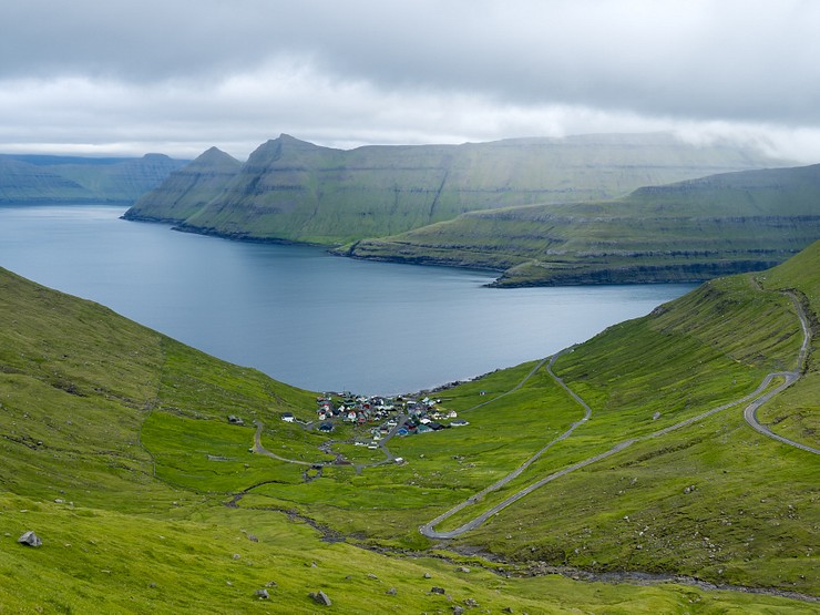
Shortly thereafter, you will get the first glimpse of Funningsfjørður. Following a few sharp turns of the road, the landscape opens up with the view of Funningur far below in a bowl-shaped valley. Slættaratindur, now behind you, is an imposing backdrop for the small village when seen from the other side of the fjord.
This is the view Funningur is known for, the narrow road winds back and forth in sharp turns until reaching the village. Going to the Hvíthamar mountain ridge, you shall not drive to Funningur, but continue north towards the village of Gjógv.
The parking at the start of the Hvíthamar hike is about 1.5km north of the intersection with the road leading down to Funningur. The northbound road, Gjáarleið, makes two sharp turns (the s-shape at the marker on the map below), and after 200m you drive over a cattle guard.
Here is a space at the side of the road where a few cars can park without obstructing the traffic. The parking coordinates are 62.2982, -6.9706.
Getting to Hvíthamar without a rental car is impractical as the location is out in nowhere between villages reachable by public transportation. From Tórshavn, you can take bus 400 towards Klaksvík. Get off in Oyrarbakki, about halfway to Klaksvík. In Oyrarbakki, switch to line 201, taking you to the village of Gjógv.
The bus passes the spot where the Hvíthamar hike starts, and if you ask kindly, the bus driver can probably let you get off the bus there. Otherwise, you must walk, hitchhike or try to find a taxi to take you back 3.5km on the road from Gjógv to reach the start of the walk to Hvíthamar.
An alternative is to join a guided tour with transport included. See the Tours to Hvíthamar section at the end of the post for tour suggestions.
From the parking, it’s a straight hike up the mountainside to reach the lower part of the Hvíthamar ridge. A cattle fence runs all the way from the parking up to the top. The walk along the left side of the fence takes about 15-20 minutes.
The view of the fjord is best from the top, but Funningur is not visible from the ridge. If you want to see the village from Hvíthamar, don’t walk up the mountain. Instead, turn right and climb over the fence using a ladder next to the parking.
There is a path in the south-eastern direction leading to the village viewpoint. It’s probably difficult to see the path unless it has been marked since I visited, but if you head in the direction towards the village, you should be fine. Here is a video showing the hike to the village viewpoint starting from the parking.
I didn’t go to the village viewpoint myself, but I think it’s possible to make a detour and go there on the way down from the ridge instead of walking back to the car the same way. The southern side of the mountain isn’t steep.
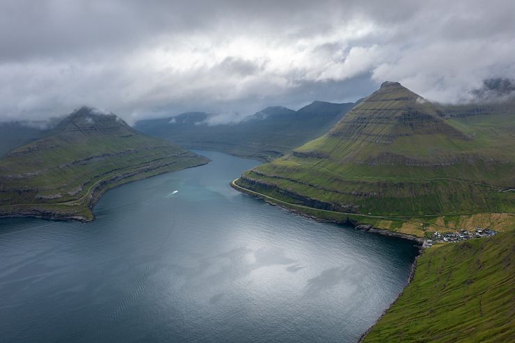
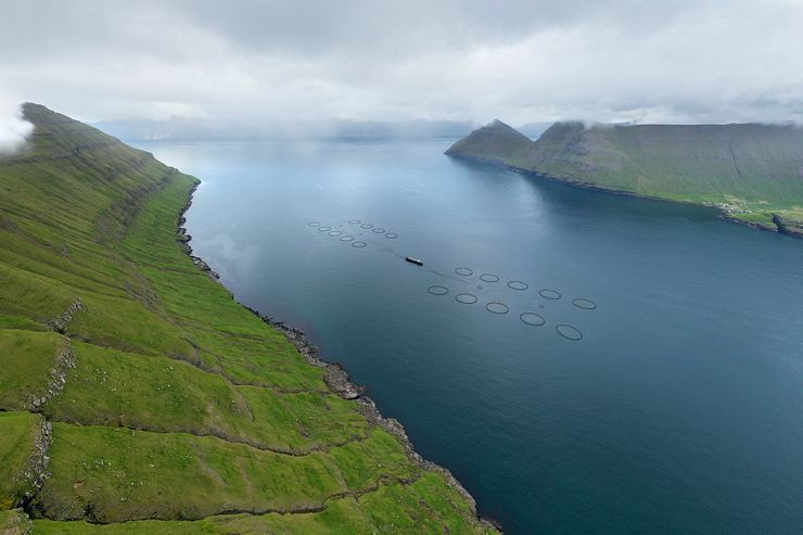
After the strengthening walk up to the top, it’s time to explore the Hvíthamar ridge. In clear weather, you have an amazing view of Funningsfjørður as it meanders south towards the center of Eysturoy.
Two mountains guard the entrance to the narrower passage of the fjord. To the right stands Húsafjall (695m/2280ft) and to the left rises the slightly higher Dalkinsfjall (719m/2359ft). Funningur is hiding in the valley at the foot of Húsafjall.
I had no luck with the weather, and despite spending quite some time on the mountain waiting for the clouds to clear, it didn’t happen. Even with the low clouds, the view was superb and worth the time and effort to hike Hvíthamar.
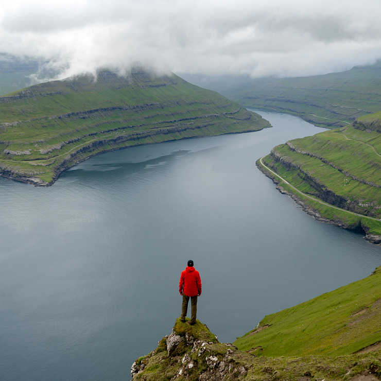
To get different perspectives, you can walk the ridge both south towards the village and north to the higher parts, which have the slightly better view in my opinion.
Judging from Instagram posts, the most popular photo spot is south of the point where you enter the ridge. There are a couple of stones on which you can stand and look out over the fjord to get an eye-catching photo when taken from the right angle.
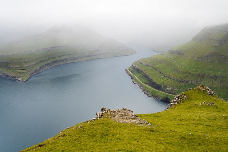
I didn’t have a clear view of the fjord and walked further north instead. The ridge is like a flight of stairs with a series of plateaus forming the steps. To reach the next plateau, you must walk on the mountainside just below the ridge.
Follow a narrow path on the side facing the valley. Down to your left, you see the parking and the road to Gjógv running north through the valley.
You don’t have to walk that far until the right side of the path changes from a rock wall to easier terrain where you can walk up to the next ridge plateau.
There are several good photo spots along this part of the ridge. Straight to the east, across the fjord from Funningur, is the village of Elduvík. Further to east, beyond Funningsfjørður, is the long and narrow island of Kalsoy with one of the top sights in the Faroe Islands, the Kallur lighthouse.
If it’s still there, you will have a nice bird’s-eye view of a fish farm down at the fjord, a common sight in the Faroe Islands.
The whole activity, including walking up and down plus spending time at the ridge, takes 1-1.5h. Or even less if you only take a quick look at the view and snap some photos.
From the parking at Hvíthamar, it’s a five minute drive north to visit Gjógv. The village is named after a 200m long gorge running from the sea into a protected natural harbor. You can do a short hike up the hillside north of town to get a nice view of the surroundings.
The land is private property and the landowner charges 50 DKK for the hike (August 2019). Pay by putting cash in a box at the start of the walk.
Gjógv is at the end of the road, so after spending time in the village you must drive back south on the same road until reaching the intersection with the road leading down to Funningur. If the weather is clear, it might be a good time for a hike to the peak of Slættaratindur.
I have done the hike (from Eiðisskarð), but I can unfortunately not tell you anything about the view, because I didn’t see it. It was cloudy, and I saw nothing from the top. I’ve heard that it can be great on a clear day.
"Tourists routes in the Faroe Islands are called Sóljuleiðir (Buttercup routes), named after the Faroese national flower. On tourist routes you can drive slowly and enjoy the trip and the stunning surrounding nature without disturbing the traffic on the main roads."
If you drive down to Funningur for a quick stop in the small village, you can continue to drive around Funningsfjørður on the two scenic buttercup routes Funningsleið and Elduvíkarleið. From the eastern side of the fjord, you will see Funningur below Slættaratindur.
Hvíthamar is not visible in the photo above, but the mountain is to the right of Funningur. Driving Elduvíkarleið all the way to the end brings your to Elduvík. It takes about 15-20 minutes to drive from Funningur to Elduvík one-way.
This section contains affiliate links. When you make a purchase of a tour through a link, I may earn a small commission at no extra cost to you. Thanks for your support — it helps keep the site afloat.
Without your own wheels and with the hassle of less‑than‑ideal public transportation, joining a guided tour to Hvíthamar is a convenient alternative. I recommend checking out Guide to Faroe Islands. They offer a wide selection of tours to destinations all over the Faroe Islands.
Hvíthamar is becoming a popular spot, though it’s still not on the main tourist route. For now, only a few tours are available, and most share a photography focus. It’s an incredibly photogenic location, and with even decent weather you’ll come home with beautiful shots of both the Funningur fjord and the Gjáarskarð mountain pass.
Of course, you don’t need to be a photographer to enjoy these tours—you’ll still collect wonderful memories from the stunning scenery. Still, having an interest in taking photos will likely make the experience even more rewarding.
The Spectacular 7 Hour Eysturoy Island Day Tour covers several of the island’s highlights, including Hvíthamar and Gjógv. It’s a small‑group tour that starts in Tórshavn.
Eysturoy Island – The Photography Tour is a full‑day trip that takes you to three beautifully situated villages. After exploring Gjógv, you’ll walk to the Hvíthamar viewpoint before continuing along the mountain road for a superb view of Funningur. The final stop is the remote village of Tjørnuvík with its black‑sand beach. Even if you don’t join this tour, these villages are well worth visiting. Pickup is available in Tórshavn or from other locations.
For multi‑day tours that cover several of the Faroese islands, take a look at The 5 day Photography Tour – Faroe Islands highlights and The 4 day Photography Tour - Faroe Islands highlights. The itineraries are similar, and both include the Hvíthamar mountain‑ridge walk. Accommodation is not included, only the photo guide and transport.


Comments
Comments are closed. Contact me if you have a question concerning the content of this page.